Flood warning for Montezuma County; seven roads listed closed
The weather service calls the flooding across southwest Colorado significant and historic, and advises people in the warned area not to travel overnight. County emergency management lists seven roads closed and six more with water or debris across them.
The National Weather Service put Montezuma County under a flood warning at 4:08 p.m. on Sunday, replacing the flood watch that had been in force since early morning, and Montezuma County emergency management has listed seven roads closed and six more with water or debris running across them.
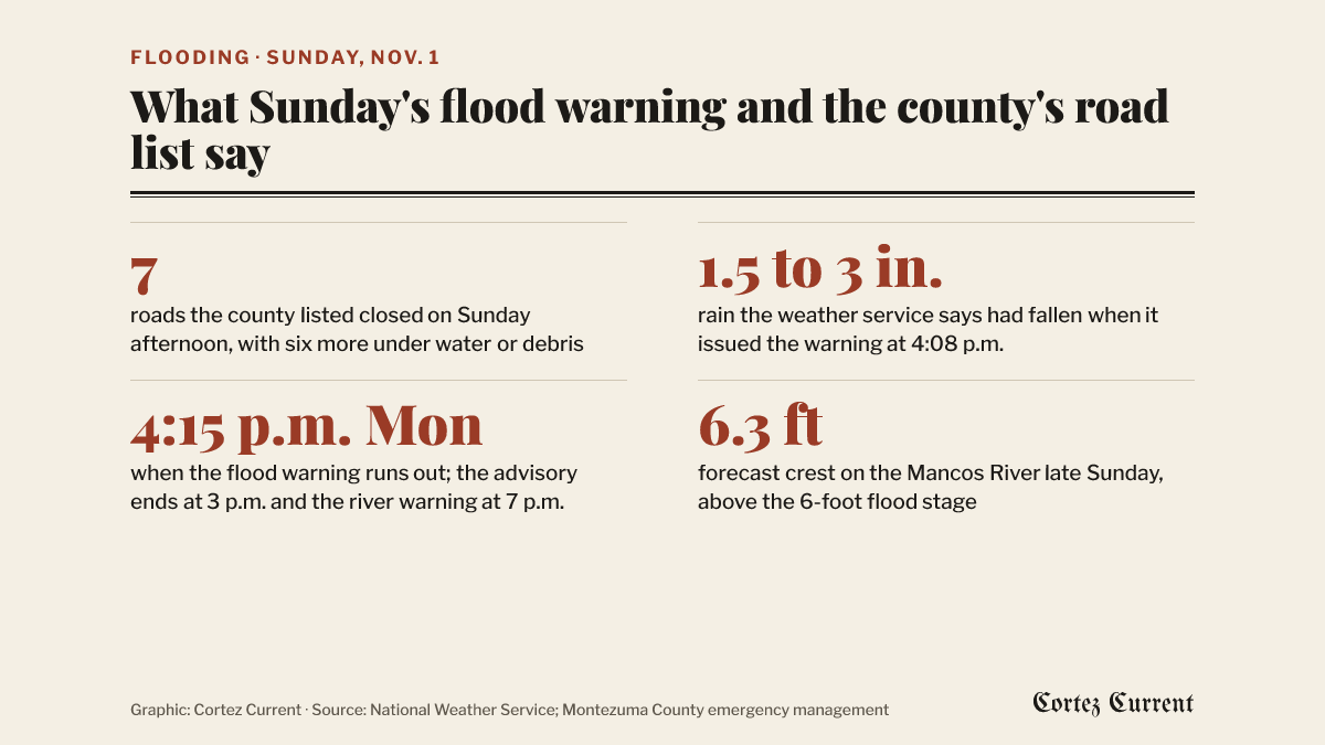 Graphic: Cortez Current. Source: National Weather Service Grand Junction; Montezuma County emergency management
The warning runs until 4:15 p.m. on Monday. Its opening lines read: “Significant and historic flooding is occurring across southwest Colorado and southeast Utah. Widespread rainfall will continue through Monday.” The bulletin says many local roads “have become flooded and impassable” and that some “have washed out, or collapsed completely,” and adds: “If you live in the warned area, it is recommended to not travel this evening or overnight. This is a PARTICULARLY DANGEROUS SITUATION.”
The capital letters are the weather service’s own. The phrase is one the Grand Junction office reserves for the small number of events it considers unusually serious, and it has not appeared in any of the flood products the Current has reported in Montezuma County this month.
The warning covers Montezuma County in full, along with western Archuleta, western Dolores, southeastern La Plata and west central San Miguel counties in Colorado and southern San Juan County in Utah. Among the places it names that flooding will reach are Cortez, Dolores, Towaoc, Arriola, Yellow Jacket, Lewis and Hovenweep National Monument.
Between 1.5 and 3 inches of rain had fallen when the warning was issued, the bulletin says, citing a report of heavy rain from local law enforcement at 3:59 p.m. Under impacts it states that flooding of rivers, creeks, streams and other low-lying ground is occurring and that “numerous roads remain closed due to flooding.”
What the county says is shut
Montezuma County emergency management posted an alert on the county’s Facebook page at 1:23 p.m. on Sunday and added a list of trouble spots to it through the afternoon. It says flooding is affecting low-lying areas and that heavy rain and runoff would continue “for the next 18 hours.”
The alert lists these roads as closed:
- Road G at the 21,800 block, by a mudslide
- Road 20 West between Road Z and Highway 491, where the road is washing out
- Road 21 between Road S and Road P
- Road 21 south of Road G, where the road has washed out
- Road 21 at the 6,499 block, where a tree is down across the road with water flowing
- Road P between Road 23 and Road 25
- Highway 41 at mile marker 7.9, which the county said at the time it expected to reopen within the hour
It lists six more places where water or debris is crossing the road without saying they are closed: Highway 160 at Highway 491 south; Road G at the 4,000 block, where boulders are in the roadway; Road 31 at the 19,000 block, a mud and rock slide; Highway 184 at Road 22; Road S at Road 21; and Road N at Road 25.
The county’s own note on how complete that list is: “Road and Bridge is attempting to sign and inspect roads, but they are also too busy to check all the areas and to keep up with the flooding. Have patience.” Earlier on Sunday, at 12:35 p.m., the Road and Bridge Department said it was responding to multiple reports of water flowing across county roads.
A reader looking for the state highways should check cotrip.org, which is the Colorado Department of Transportation’s own record of what is open. As of 5 p.m. Sunday it listed no closure touching Montezuma County, which does not match what the county and the weather service describe on the county roads — the two sources count different roads, and COtrip does not carry county roads at all.
The Mancos River
Separately, the weather service issued a flood warning for the Mancos River near Mancos at 10:50 a.m. on Sunday, running from Sunday evening to Monday evening. It forecasts minor flooding.
The river stood at 4.8 feet at 10 a.m. Sunday. Bankfull is 5 feet and flood stage is 6 feet. The bulletin expects the river to rise above flood stage during the evening and crest at 6.3 feet late Sunday, then fall back below flood stage late in the night. At 6 feet, it says, minor flooding can be expected around Mancos. The forecast crest would be the highest the gauge has recorded since a 5.7-foot crest on May 21, 2005. The office said its next statement on the river would come at 7 p.m. Monday.
A third product, a flood advisory issued at 3:07 p.m. and running until 3 p.m. Monday, covers the same six counties and warns of debris from mudslides, water over roadways and low-water crossings becoming impassable.
The three rungs
A watch means flooding is possible; a warning means it is happening or about to. Sunday’s warning is the step up from the flood watch the weather service issued on Thursday night and reissued on Saturday, which was still due to run until 11 a.m. Monday and remains active alongside the warning for the wider forecast area.
The rain is falling on ground already saturated by last week’s storms, which shut US 160 west of Cortez for three days, put rockfall on Road G and sinkholes on Road J, added about 20,000 acre-feet to McPhee Reservoir and led CDOT to ask Washington for $65 million in emergency repair money.
Tuesday is Election Day, and the county’s voting centers and ballot drop boxes are listed in the Current’s voter guide. The county has not said anything about the weather affecting them.
Reporting a problem
The weather service’s advice with all three products is the same: “Turn around, don’t drown when encountering flooded roads. Most flood deaths occur in vehicles,” and be especially careful at night, when flooding is harder to see. The Road and Bridge Department adds that six inches of moving water is enough to knock an adult over and about a foot will carry away most cars.
The county gave two different non-emergency numbers for reporting flooding in its two Sunday posts: the 1:23 p.m. emergency management alert asks people who see major flooding to call dispatch at 970-565-8454, and the 12:35 p.m. Road and Bridge post gives 970-565-8441 for reporting damage. Both are the county’s own. For an emergency, both say to call 911.
The warning, the river forecast and the advisory are all on the weather service’s active alerts page, and the Grand Junction office’s forecast is at weather.gov/gjt. Any active watch or warning also shows by itself on the alert bar at the top of every page on this site.