State snowpack is 288% of normal; local gauges read near zero
A number making the rounds on social media is true and almost meaningless this early in the season. Of eleven mountain measuring sites in and around Montezuma County, five showed no snow water at all on Sunday morning.
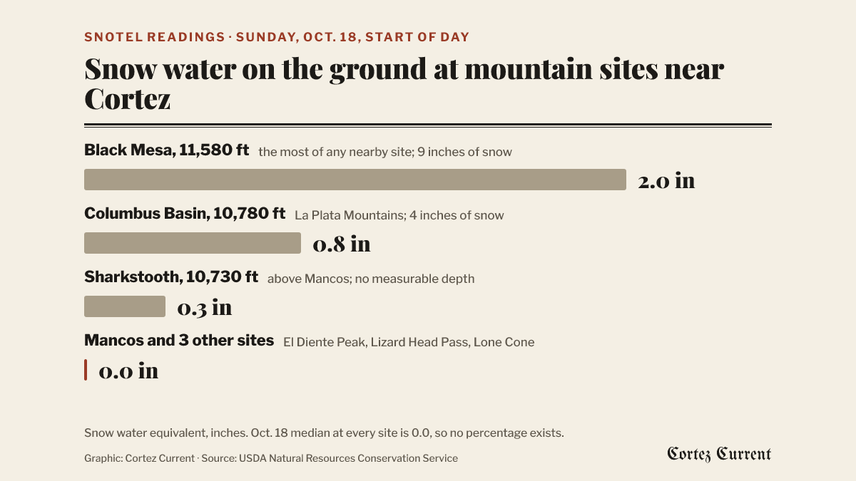
Colorado’s snowpack stood at 288 percent of normal for the date on October 14, and a version of that figure — “500 percent” — was being passed around local Facebook groups over the weekend as a sign that winter is already a success. The mountains around Cortez tell a quieter story.
Of the eleven automated snow-measuring sites in Montezuma, Dolores, San Miguel and La Plata counties, five recorded 0.0 inches of snow water at the start of the day Sunday, according to the USDA Natural Resources Conservation Service, which runs the SNOTEL network. The Mancos site, at 10,020 feet, was one of them. So were El Diente Peak, Lizard Head Pass, Lone Cone and Vallecito.
Graphic: Cortez Current. Source: USDA Natural Resources Conservation Service, SNOTEL readings at the start of the day, Oct. 18, 2026
Why the big number is true
Snowpack is measured as snow water equivalent, the depth of water that would result if all the snow on the ground melted at once. The statewide median for mid-October, built from 1991 through 2020, is about 0.1 inches. On October 14 the state’s sites averaged about 0.3 inches, which the Denver Gazette’s Out There Colorado reported as 288 percent of normal. Three-tenths of an inch is the amount Colorado typically reaches around October 23, so the state is running about a week ahead.
Dividing a small number by a smaller one produces a large percentage. The same storm in January, when the median is measured in inches rather than tenths, would barely move the figure.
Around Cortez the arithmetic cannot be done at all. The 1991–2020 median for October 18 at every one of the eleven local sites is 0.0 inches, so the agency’s reports leave the percent-of-median column blank for all of them.
What is on the ground here
The readings, from the start of the day Sunday:
| Site | Elevation | Snow water | Snow depth |
|---|---|---|---|
| Black Mesa | 11,580 ft | 2.0 in | 9 in |
| Alta Lakes | 11,290 ft | 1.7 in | 8 in |
| Stump Lakes | 11,230 ft | 1.4 in | 2 in |
| Columbus Basin | 10,780 ft | 0.8 in | 4 in |
| Sharkstooth | 10,730 ft | 0.3 in | 0 in |
| Scotch Creek | 9,160 ft | 0.1 in | 0 in |
| El Diente Peak | 10,210 ft | 0.0 in | 0 in |
| Lizard Head Pass | 10,190 ft | 0.0 in | 0 in |
| Mancos | 10,020 ft | 0.0 in | 0 in |
| Vallecito | 10,740 ft | 0.0 in | 0 in |
| Lone Cone | 9,730 ft | 0.0 in | 0 in |
The snow that fell during last week’s winter weather advisory is holding only on the highest ground. Columbus Basin and Sharkstooth, the two sites in the La Plata Mountains closest to Mancos and Cortez, are showing less than an inch of water between them, and Sharkstooth’s snow depth sensor reads zero even as its pillow registers a trace of water.
Why it matters more than usual
Last winter was the worst on record at many Colorado sites. On January 1, 2026, the NRCS reported that statewide snowpack was 56 percent of median and that 38 percent of sites with at least 20 years of records were at their lowest ever for the date. Southwest Colorado’s basin had the most precipitation of any in the state that autumn, 116 percent of median, but much of it fell as rain. Runoff came early and the seasonal volume was reduced, the agency said in the spring.
September’s rain eased Cortez out of extreme drought, but the water that fills McPhee Reservoir and the irrigation ditches next summer comes from the snow that accumulates between now and April, not from what is on the ground in October.
The week ahead
Cortez itself is not in line for snow. The National Weather Service forecast for the city, read Sunday evening, calls for highs in the mid-60s Monday and Tuesday, then an 80 percent chance of showers and thunderstorms Wednesday, 90 percent Wednesday night, and showers continuing Thursday and into Friday morning with highs falling to about 54 by Friday. Lows stay in the 40s until Friday night, when the forecast low is 37. The weekend clears, with highs in the upper 50s.
Snow levels in that system will determine whether the mountain sites gain anything. The Gazette’s report noted that the National Oceanic and Atmospheric Administration’s outlook for December through February leans toward above-normal precipitation across more than half of Colorado, with no part of the state leaning dry.
Sources: NRCS SNOTEL report generator, start-of-day readings for Oct. 18, 2026 · Out There Colorado, Denver Gazette, Oct. 14, 2026 · NRCS Colorado, Jan. 2026 · NRCS Colorado, spring 2026 · National Weather Service forecast for Cortez